Tihany was awarded the EUROPE DIPLOMA of the Council of Europe on 1 July 2003
The Tihany peninsula is unique in several respects, not just in Hungary, but also in Europe. Its special geographical position, the uniqueness of its formation, the appearance of today's scenery, the geological and historical relics along with its rare plants and wildlife all enhance its status as one of our most beautiful and most valued treasures. Natural historians and nature conservationists have been familiar with the treasures of the Tihany peninsula for a long time. The first nature conservation area in Hungary was developed here in 1952. The Landscape Protection Area of Tihany later expanded to the north, and its 1658 hectares became a part of the Balaton Uplands National Park. It has two specially protected areas: Bozsai Bay and the Outer Lake. Environmental protection management, ecotourism and the environmental education responsibilities of the region are carried out by the Directorate of the Balaton Uplands National Park (Balaton-felvidéki Nemzeti Park Igazgatóság). Their objective is twofold: to show and to protect. The contradiction can be resolved, but the solution is in your hands. Please follow the restrictions!
The shore of the Lake Balaton and the Bozsai Bay
The south-western shoreline of the peninsula remains in a near natural state, in particular the section from the part below Gurbicza to the ferry terminal has remained intact. The shore preserves its natural state at Sajkod and in the Bozsai Bay. Bozsai Bay is one of the last almost undisturbed reed bays of the Lake Balaton. White water lilies bloom on islets among the reeds. Hay-fields, meadows and the remains of fenlands run along the bay on the shore, where lax-flowered orchids, common cottongrass and Siberian iris grow, along with a host of other protected plants. The reeds offer nesting sites to many rare bird species, such as the summer goose and the western marsh harrier. Among the mammals, the specially protected otter is noteworthy.
The lakes of Tihany
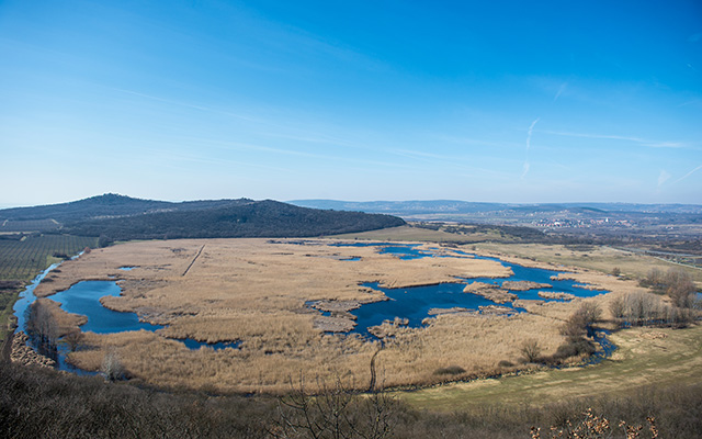
Three lakes play important roles in the beauty of the Tihany landscape: Lake Balaton, the Outer Lake (Külső-tó) and the Inner Lake (Belső-tó). However, this list is not complete, because in rainy years, a fourth lake also appears: the Rátai-csáva. All the three internal lakes of the peninsula were created in volcanic craters by simply collecting rainwater. This fact explains why they dry out temporarily. All three have done so in recent centuries. The Inner lake is situated right below the village and it is almost perfectly round with a clear water surface. It lies 26 m above the level of the Lake Balaton in a sunken caldera created after a volcanic eruption. Once it was famous for its rich flora and fauna, today it is a popular fishing place. Formed in the main crater of the peninsula's volcano, the Outer Lake is a heavily silted up, shallow lake 116 m above sea level. During the early 1800s, drainage canals were dug to carry the water away via the Aszófő-séd stream into the Lake Balaton. The drained area was utilised for hay-making. In 1976, the management of the area was granted to the nature preservation authority of the time. This is when the restoration of the original condition of the lake was begun, by blocking off the drainage canal. Since then, the water flora has totally resettled and fauna characteristic of wet habitats has also appeared. Insect life relying on water is diverse, several rare dragonflies have found suitable conditions for survival here. Of the large number of amphibians and reptiles living in the lake, there is an outstanding abundance of European pond turtles. Birds nesting here for some time now are the greylag goose, the great bittern and the western marsh harrier. In the last few years extensive breeding colonies of great egrets and purple and grey herons have formed. The third lake of the peninsula, the Rátai-csáva, was also originally created in the crater of a volcano, with no outlet. Its surface area, however, hardly reaches an acre even in the spring of rainy years. The small lake usually dries out by the end of the summer.
The remnants of the caldera rim
The basis of the peninsula is the limestone and marble of the upper Miocene shallow seas about 100 m under the surface, layered on Triassic sediment, Permian sandstone and phyllite. A series of Pliocene-Pannonic sediments were layered on this substrate (the fossil known as the ‘Tihany goat’s nail’ of the Pannonic layers is formed from the remains of the shell Congeria ungula caprae). After the Pannonic sea had receded, a basaltic volcanism process started in the region. The centre of the volcanic activity was the place of today’s Outer Lake. This is when the typical basaltic tufa layers with their red sandstone bombs were created. The remnants of the rim of the former volcano’s crater can be seen today as a series of stand-alone mountains around the Outer Lake: Csúcs-hegy, Nyereg-hegy, Apáti-hegy, Kiserdő-tető and Óvár.
Csúcs-hegy
 As a result of the intensive post volcanic activity, a whole row of geyser cones was formed on the peninsula. One such cone is the Csúcs-hegy (Peak Hill). You can still see the spring cone and the stack carved by the hot water bubbling up from the deep in the highest point on the peninsula (235 m). The geyserite 'cap' above the basaltic tufa resisted the forces destroying the mountain, and the current interesting shape was thus formed. The cliffs rising like cones are made up of sheet layers of hydroquartzite, silicic limestone and mass geyserite. Folklore has it that the spring cave on the western side was once used by the famous outlaw of the Bakony hills, Jóska Sobri.
Nyereg-hegy
Nyereg-hegy (Saddle Hill) is a narrow cliff ridge connecting Csúcs-hegy and Apáti-hegy. It offers a wonderful view of the Balaton Uplands, the southern basin of the Lake Balaton and the Bozsai Bay in one direction and the inside of the peninsula in the other. This wedge-shaped ridge is one of the most valuable geological formations on the peninsula. Post-volcanic activity brought boiling water to the former surface. Lake hydroquartzite bearing plant residues and thinly layered silicic limestone were formed in the small and large warm water lakes. The shape of the capriciously creased limestone sheets is the result of the former movements of water and crust.
Apáti-hegy
This is the section of the caldera rim closest to the Outer lake. On the eastern side, the surface level drops via steep basaltic tufa cliffs to the lake. Rock formations carry the mark of the destruction caused by the wind. An unforgettable experience is offered by the view to the inside of the peninsula, the Outer Lake, the Inner Lake and the ancient village with Balatonfüred in the distant background. On the north side, marking the site of the former village of Apáti, are the Apáti church ruins. The Apáti-hegy (Apáti Hill) is one of the most valuable habitats on the peninsula. On the top of the hill, a whole line of Mediterranean and sub-Mediterranean plants grows on secondary meadows, among them the Sternbergia colchiciflora, the autumn ox-eye daisy, the dwarf morning glory, and the Valerianella pumila. You can also find here the prickly Lucerne and several species of feathergrass along with the dwarf iris. Flowering on the eastern side of the cliff is the Early Star-of-Bethlehem, the Cotoneaster matrensis and the scorpion senna. This southern climate also favours insects. Large-bodied froghopper species generally rare in Hungary can be found here, such as the red cicada and the Cicada orni. This, however, does not conclude the list of distinguishing features of the Apáti-hegy. The southern side of the hill retains the last of the once famous lavender plantations of the peninsula. Some of the original vegetation has returned since cultivation was abandoned. Plant-life characteristic of sloping steppes thrives among the lavender stocks, forming together a unique habitat which is home to a number of precious plants and animals. Another – and likely also a leftover from previous cultivation– plant of the area is the woolly foxglove which is under special protection. Among the protected insects of the lavender plant, Lioderina linearis is worth mentioning.

Kiserdő-tető (Small Forest Peak)
This is the remnant of the caldera rim rising between the Outer and the Inner Lakes in the central part of the peninsula. The basalt cliffs formed during volcanic activity have been dislodged from their original place by later land movements. Wind has demolished the softer rock, leaving the harder basaltic tufa to withstand the destructive forces. The top of the mountain is covered with a sloping steppe of cliff grass and prairie grass, and several species of oak bush forests grow round the sides. In the autumn, the reddish colour of oak is very picturesque with the Outer Lake in the background.
Óvár
 This striking ridge marks the eastern side of the peninsula with its picturesque basaltic tufa rock formations facing Lake Balaton. Along its summit runs the most beautiful Iron Age earth fortification in the Lake Balaton region. Pannocic grasslands lie close to the remains of this former earth fortification, and their characteristic protected plants include the ant thistle, the large milkwort, the pheasant’s eye, the woolly cotoneaster, the pasque flower, the Pannonian knapweed and the Italian aster. This is one of the two habitats in Hungary where the round-mouthed snail lives. A series of caves carved into the 20m high basaltic tufa cliffs on the eastern side of the Óvár (Old Fort), are known as the Monk Houses, where Russian monks, brought here from the Great Principality of Kiev by the wife of the Hungarian king Andrew I around 1050, are reputed to have lived. Only three groups of cells are visible today, the rest were buried in 1952 by a rockfall. In 1984 archaeological and geological excavations revealed several skeletons. The cliff face and the still existing cells were stablised in 1994. The only layer spring of the peninsula the Orosz-kút (Russian Well) which rises to the surface nearby was named after the Russian monks. (A more common name used today is the Cyprian Spring.)
The Szarkád forest
Most of the hills on the rim of the peninsula are covered with forest. The most beautiful of these forests lies on the southwestern side and is called the Szarkád forest (Szarkádi-erdő). The main characteristic species of trees here are the oak, including some downy oak, flowering ash, field maple and field elm. Some special oaks also grow here such as the oak of Virgil. Under the shrub stratum, live many valuable herbaceous plants. Notable wildlife in the Szarkád forest are the longicorn, the stag beetle, the smooth newt and the spadefoot toad. A characteristic reptile of the forest is the Aesculapian snake. Birds are represented by the black, green, and grey-headed woodpeckers. Typical birds of prey are sparrowhawks that hunt during the day and, a true southern rarity, the long-eared owl that hunts in the night. In the southern part of the Szarkád forest, above the ferry terminal, you will find the remains of the church of the former village of Újlak.
The geyser field and the Golden House
The geyser fields prevalent between the Szarkád forest and the Inner Lake feature rock formations which arose in the Quaternary period, some three million years before our time. Hot water used to flow to the surface during the postvolcanic activities that followed the basaltic volcanism. The hot springs – similarly to the ones active in Iceland – broke to the surface in temporary geysers. From the thermal water of the springs, and the hot lakes, silica mud was deposited and transformed into solid stone. Depending on the operation of the geyser and the movement of the water and the crust, this geyserite rock solidified in different folded shapes creating 100-150 smaller and larger geyser cones. Today, you can only see about 50 of them. The biggest one is the Golden House geyser cone which was named after the yellow lichen growing all over it. Animals, such as the green lizard, that love a warm environment live in the typical undergrowth of the rock. The top of the geyser cone offers a fabulous view to the Inner Lake and the old village.

Lóczy nature trail
 Marked with a red cross, the Lajos Lóczy nature trail leads hikers to the most beautiful places and sights of the Tihany peninsula described above. The starting point is in the ruins of the Apáti church next to Sajkod. From here, the trail leads up over Apáti hegy, Nyereg-hegy and Csúcs-hegy into the Szarkád forest and then, via the Geyser field and the Golden House, to the ancient village. From there, via Kiserdő-tető, Óvár and the Monk Houses, the trail takes you to the Tihany port. There are 7 stops on the trail, each connected to one of the sights.